|
|
|||
|
Home The Streets The Families War Commerce and Trade Institutions |
|||
The
O’Cahan’s and Killowen
Ronnie
Gamble
The
O’Neill Ascendancy In
the 4th century AD Niall of the Nine Hostages was born to
Cairenn Chasdub, the daughter of a Saxon king and the second wife to
Eochaiid Mugmedon, a high king of Ireland. Niall became king of Ireland in
378 AD and went on to have eight sons. One of these was called Owen. He
and his offspring consolidated a power base throughout Ireland,
particularly in Ulster, that lasted until the 17th century. One
descendant was called Niall Glandubh (Black Knee, d. 919) and his
grandsons were given the surname Ui Niall (the grandson of Niall). This
was later Anglicised to the legendary name O’Neill. The king of the
O’Neill clan was always referred to as The O’Neill. The
O’Cahan Sept The
first recorded O’Cahan was known as Raghnall O’Cathan
(d. 1138). He had the title Lord of the Creeve, Coleraine and
Keenaght. The O’Neill had
granted these titles because the O’Cahan sept was a trusted subordinate
branch of his clan. The O’Cahan sept first branched out from the
O’Neill territory and gained control of the Bann Valley from the Fir-na-Craebh
(Men of the Creeve). They then ousted the O’Connor’s from the Dungiven
area during the Norman era. The O’Neill entrusted the O’Cahans with
the defence of the northern, western and eastern approaches to his
territory.
During
their tenure the O’Cahans sponsored the building of Dungiven monastery
and the Abbey grounds became the O’Cahan burying grounds. Their close
allies were the MacDonnell clan from County Antrim. Both groups were
educated and also instructed together in Skill-at-Arms at the monastery.
This close relationship was maintained until well after the 17th
century. For example although
Dunseverick castle was located in MacDonnell territory the O’Cahans
garrisoned it until the English confiscation after the 1642 rebellion. O’Cahan’s
Country
Before
the 1600s the Atlantic coastline formed the northern boundary of Tir-Cahan
(O’Cahan’s country). The River Foyle bound it on the west and the
eastern boundary was the River Bann. The southern boundary was provided by
the Sperrin Mountains and included the barony of Loughinsolin in County
Tyrone. Benevenagh
was in the centre of their territory and the spirit of Benevenagh was also
reputed to be the guardian spirit of the O’Cahan sept. The
Gem of the Roe There
is a traditional story told about the daughter of Cooey O’Cahan. The
marriage of Finvola, ‘The Gem of the Roe’ illustrates how marriage was
used to establish relationships and maintain the peace between the clans. During
their travels to the Courts of Caledonia the O’Cahan’s had occasion to
stop for a few weeks at the castle of the Lord of the Isles on Islay, the
MacDonnell’s. A young Angus Oge MacDonnell fell for Finvola O’Cahan
and visited her back in O’Cahan’s country. Their marriage was
solemnized in Dungiven Abbey. As part of the dowry twenty-four O’Cahan
princes had to marry twenty-four daughters of MacDonnell chieftains. O’Cahan
Ascendancy The
O’Cahans appear to have reached the zenith of their power and control of
their territory in the early fifteenth century. That was a time when the
Anglo-Normans control of their territory was fading and the Elizabethans
had not focused their attentions on Ireland, as yet.
On
some occasions the O’Neills supported or aided the O’Cahans by raiding
McQuillan territory to the east of the Bann. In 1431 the O’Neills had a
six-week campaign of destruction in the Route area. Then by 1441 there
were more serious battles between the O’Cahans and the McQuillans.
In 1513 Donnell the Cleric O’Cahan hanged Alexander McQuillan in
Coleraine town.
The fighting continued unabated, sometimes it was between the
O’Cahans themselves but usually between the O’Cahans and the
McQuillans with support from neighbouring septs such as the O’Mullans,
the McCloskeys and the O’Dohertys.
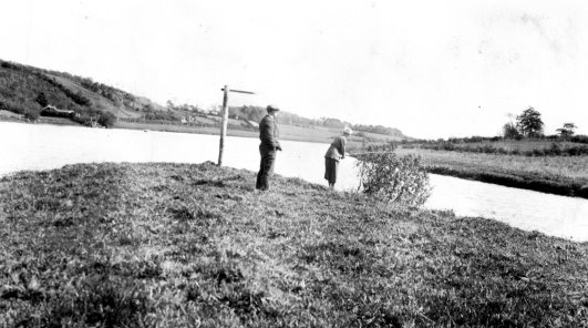
Mrs
Taylor of Ardara, Lodge Road, wife of Brian Taylor of Coleraine Distillery
fishing off the Loughan Island (South End) with her Gillie Pat Curry in
1924. Photo
Courtesy of Dan McLaughlin, (Mrs Tyler’s nephew). In
1542 the O’Donnells of County Donegal raided the Route and captured the
wooden castle on the Loughan Island from the McQuillans. It was then taken
over by the O’Cahans. In 1544 the McQuillans counter-attacked and with
the support of the MacDonnells of Antrim they burned everything on the
island, including the O’Cahans and all their possessions. After that
date the O’Cahans, McQuillans and the MacDonnells in succession owned
the Island until the 18th Century (UJA 1859, p192). The
ferocity of the fighting that took place at the Loughan Island can be
gauged by the cartloads of weapons and other artefacts that were dredged
up during the 1851 clearance of the navigation channels on the River Bann
at the Loughan. Unfortunately Loughan Island was used as a dumping ground
for the debris dredged up from the floor of the River Bann during the 1935
clearance of the navigation channel.
The
Nine Years War
In
1584 the territory of the O’Neill’s and their sub clans was
transformed. Sir John Perrott created the nine counties of Ulster in 1586
and O’Cahan’s country became County Coleraine (Forde, P58). By 1598
the warfare between the O’Cahans and the McQuillans had eased off and
the last great leader of the O’Cahan sept, Donnell Ballagh O’Cahan was
inaugurated.
Initially
Donnell Ballagh O’Cahan supported The O’Neill when he started his
campaign to rid Ireland of the English. O’Neill’s initial battles were
spectacularly successful. But the defection of the O’Cahans to the
English in 1602 undermined these successes. The O’Neill was forced to
surrender at Mellifont in the south of Ireland in 1603. That episode ended
300 years of Gaelic domination of Ulster. The murderous outrages and the
scorched earth tactics of the English army resulted in the death of many
native Irish men, women and children and the land was stripped of its
livestock and crops. O’Neill’s
Planned Uprising
Four
years after their surrender the Irish chieftains had still not adapted to
the English terms of settlement and the new capitalist regime. In
desperation the Irish chieftains planned another uprising. But
O’Neill’s position became even more precarious when The O’Cahan, Sir
Donnell Ballagh O’Cahan started a land dispute with him. It has been
alleged that Sir Donnell Ballagh O’Cahan was aware of The O’Neills
plan for another insurrection in Ulster (Sampson 1814, p207). In 1607,
just after he was summonsed to London to settle the O’Cahan land dispute
The O’Neill decided to leave Ireland. This forced The O’Neill’s hand
and he deserted his people by fleeing along with his minor chiefs and
their families to the continent in what became known as ‘The Flight of
The Earls’. Land
Confiscation
The
Flight of the Earls gave the English Crown the excuse to confiscate the
deserted ancestral land of the O’Neills and the minor chieftains. This
territory covered six of the nine counties of Ulster including Donegal,
Tyrone, Armagh, Fermanagh, Cavan, and Coleraine. The Crown then planned to
plant English and Scottish settlers on the confiscated land, a process
that became known as the Plantation of Ulster.
For
a short period the principal town of Coleraine was located on the west
bank of the Bann at Drumtarsey. When Coleraine was relocated on the east
bank of the river Bann, the territory was renamed County London-Derry.
Earlier records on the local names were lost during Sir Cahir
O’Doherty’s rebellion in 1608 when Derry city was burnt. Sir Cahir
O’Doherty of Inishowen was provoked into a short-lived rebellion against
his tormentor. In April 1608 he seized the fort at Culmore and burned
Derry city. His eventual death led to more confiscations of native Irish
territory. All the ecclesiastical records for the area were destroyed
during this insurrection and the Montgomery manuscript dates the renaming
of Drumtarsey as Killowen to approximately 1607. Despite
being accused of disclosing details of the insurrection and siding with
the English again, Sir Donnell Ballagh O’Cahan came under suspicion and
had to surrender to Sir Thomas Philips. In 1608 he was incarcerated in
Dublin Castle for two years and then transferred to the Tower of London.
The treachery of the Crown was not all that kept the O’Cahan interned
without trial until his death in 1628. His own family were queuing up to
condemn him in return for a re-grant of part of his territory. That
treacherous list included the names of Maus O’Cathain, Gilduff
O’Mullan and Dennis O’Mullan. Their accusations were all accepted but
the re-grants never materialized. The
Plantation of Ulster
The
main purpose of settling English and Scottish Protestants in Ulster was to
enforce the English form of centralized governmental control of Ireland.
The control of Coleraine castle, the Bann Bridge and Coleraine town had
great strategic significance for the English. Although the Scots on the
east bank of the Bann and the Irish on the west bank were prone to minor
skirmishes with each other, they also cooperated when they were under
attack. This cooperation was terminated when Coleraine was planted as a
garrison town. The Irish to the west of the Bann now had their escape and
supply routes firmly closed.
The
Plantation was also designed to prevent France from using Ireland as a
back door into England and prevent Spain from forming a strong alliance
with the Irish. Finally, the Plantation was used to shift the lowland
Scots from Scotland where the land could no longer support a growing
population. The Londoners’ Plantation In
the opening stages of the plantation 12 London Livery Companies were
detailed to administrate the territory. They showed a marked reluctance to
accepting this business venture. It took a series of threats and
inducements from the Crown before they accepted their responsibilities.
By
the time the Londoner’s Plantation started in 1613 Coleraine County had
another name change. It was now known as County London-Derry and the
capitol was now called London-Derry. The area was then settled much
differently than the other five counties. The first grant of land was made
to The Irish Society who was directly responsible for developing
London-Derry city and Coleraine town and their attached Liberties
(surrounding lands).
The
second grant within the county was made to the twelve London Livery
companies who acted as landlords. One of the best-known Livery Companies
was the Clothworkers who were granted the land on the west of the Bann.
They were responsible for building the Clothworker’s building at the end
of the Bann Bridge and developing the Killowen area.
The third grant amounted to twenty-five percent and that was issued
to the native Irish freeholders. Many of these native freeholds would be
lost through confiscation by the Crown when the freeholders were
implicated in the conspiracies and rebellions that would follow over the
next two centuries.
Other
grants were issued to smaller numbers of people such as Sir Thomas
Phillips who had lost property in Coleraine in the redistribution.
Finally, the Protestant Bishops were also granted land. Any map outlining
this allocation of land in Co. London-Derry for that period is represented
by a patchwork of approximately 150 plots of land covering the whole
county. Land
Confiscation Native
Freeholders were granted land at the start of the plantation. Despite the
intentions of the London administration, there were still more Native
Irish tenants than settlers in the confiscated lands in 1613. Many of the
Irish freeholds were lost through confiscation by the Crown after the
native freeholders were implicated in conspiracy or rebellion against the
settlers. The confiscated property was reallocated to the settlers, former
military leaders who then leased the land out to the settlers.
By
the year 1700 the victorious Williamite and Cromwellian armies had
confiscated most of the land belonging to the native Irish throughout
Ireland. Tristram Beresford of Coleraine was either granted or bought much
of O’Cahans freeholds and left them in his will to his children (Mullin
& Mullan, P157). The
O’Cahan Conspiracy In
1614 Alexander McDonnell’s servant was about to be hanged in Coleraine
as “an idle person”. (Curl, 2000, p95) He saved his life by claiming that he had
knowledge of a conspiracy by the displaced Irish to attack Coleraine town.
He alleged that a meeting had taken place three miles from Coleraine on
the banks of the Bann near Macosquin.
It
was further alleged that Rory O’Cahan, the son of Sir Donnell Ballagh
O’Cahan who was now in the Tower of London, was the leader of the
conspiracy. He and others planned to obtain weapons from a disaffected
guard in the town. After that, they would use the guard to gain access
into the town after the curfew. Their next step was to take two London
Agents as hostages until Sir Donnell O’Cahan was released, kill the
remainder of the inhabitants and then burn the town down.
From
other information given under torture it was shown that this rebellion was
in contrast to the 1608 O’Doherty rebellion. The O’Cahan plan appeared
to be much more elaborate and involved simultaneous attacks on Lifford,
Derry, Culmore and Limavady (Gillespie, p15). Of the seventeen
conspirators, eleven were acquitted and the remaining six including Rory
and Gorry O’Cahan were hanged. The priest O’Laverty were hung, drawn
and quartered in Derry and his severed head was spiked over the gates of
Derry. The
Elcock Ransom Then
in 1616, three years after the town received its Charter the Irish Society
became responsible for the town garrison and Nicholas Elcock had been
appointed the agent responsible for the development of Coleraine. Elcock
was captured by one of the MacDonnell’s who held him for ransom until he
managed to escape with the help of the Native Irish. MacDonnell was
eventually captured and beheaded; his head was displayed in Coleraine
(Curl, 2000, p378). The
1641 Rebellion In
the early 1630s the Irish Lordships were in despair due to the crop
failures and their poor management skills under the English system. To add
to their despair, Court officials were appointed by King Charles I to
raise money by any means and also enforce High Church conformity. Their
tactics became the catalyst for the rebellion against
the English and Scottish settlers led
by Rory O’Moore in 1641. On that date Randall MacDonnell the 2nd
Earl of Antrim removed himself from the area and was residing in Dublin.
Coleraine
town mustered over 650 men in eight companies under the command of Colonel
Edward Rowley of Castleroe. This was a citizens’ militia raised from
volunteers who were prepared to deal with the rebels. But the town had to
disarm a company of fifty Roman Catholics after they received news of the
Portna Massacre. That massacre took place when Irish and Highlander troops
led by Manus Roe O’Cahan were sent out to stop the advance of the Irish
across the Bann into the Route. This treacherous group massacred the loyal
troops. The rebels, led by the Dunseverick O’Cahans, Gillduffe and his
son Turlough Oge, then advanced through the Route burning and killing as
far as Ballintoy. There they laid siege to the Protestants in Ballintoy
Church. The Protestants, sustained on oatmeal smuggled in by the Catholic
priest Father McGlaim, called out ‘No Surrender!’ to their besiegers
and successfully held out (McSkimin, 1906). Turlough and Manus Roe
O’Cahan also took part in the burning of Dunluce town.
Another
attempt to halt the rebels took place in Garvagh. Edward Rowley and
William Canning were put in command of 300 men at the Battle of Garvagh.
During the second battle they fell to 1,000 Irish rebels on 13 December
1641 at Rowellan’s Hill just outside Garvagh. Most of the settlers were
killed, including Canning. The rebels continued their slaughtering and
burning on their way to Coleraine. At McCaskey (Macosquin) the rebels
stripped Thophilus Vesey, the son of the Rector of Macosquin, and six
other Vesey children naked. They were then allowed to make their way to
the safety of Coleraine town.
One
of the early criticisms of Coleraine was that it was too large to be
defended. It now proved to be barely adequate to house the thousands of
refugees flooding in. Before long the overcrowding, malnutrition and
disease had the refugees dying at the rate of 150 each day. A mass grave
was dug to accommodate 2,000 bodies at one stage of the 140-day siege.
There are scant records but some excavations do indicate that a mass grave
was located in the area of the present Northern Constitution Offices in
Abbey Street. On 11 February 1642 one of the Coleraine Captains
of the citizens’ militia, Archibald Stewart deployed from Coleraine. He
moved along the Bann shore towards Glenstall near Ballymoney. The general
plan was to attack the rebel army. He had 300 English and 600 Scottish
Protestant troops under his command that day. The rebel army under the
command of Alastar McColl MacDonnell, a kinsman of the 2nd Earl
of Antrim attacked him first. The rebels fired one volley from their
muskets and then mounted a Highland charge on the Coleraine forces who
were very quickly routed. Over half the loyal troops were killed. One of
those killed in the battle was the Rev John Campion, the Rector of
Killowen church. That particular day became known as ‘Black Friday.’ Sir James MacDonnell, James McHenry and Allester
MacDonnell led the main body of the rebels at that stage. They camped in
the Ballyrashane area while Coleraine town was besieged. Then in early May
1642 the 2nd Earl of Antrim returned to his territory and broke
the siege by allowing food to be taken into Coleraine. He then helped to
route the rebels. The navy also sent small boats up the Bann to relieve
Coleraine. The Laggan Army based in the Foyle area slaughtered many rebels
of the McGilligan sept to the north west of the Bann and then relieved the
town on 16 May 1642.
The
Scottish Presbyterian troops of Major-General George Munroe also relieved
the town near the end of June and the Scottish Army became the garrison
troops until 1649. Munroe took the time to destroy all the castles on the
Antrim coast with the exception of Dunluce and one wall of Dunseverick
Castle that proved to be too robust.
The
Scottish Presbyterian grip on Coleraine was only broken on Sunday 23
October 1649 when Sir Charles Coot’s Parliamentary army threatened
Drumtarsy castle from the high ground where Upper Captain Street is now
located. His army also crossed the Bann at the Barmouth and Lieutenant
Colonel Tristram Beresford rowed up the Bann to Coleraine with enough
troops to win Coleraine back again. Gillduffe
O’Cahan and his son Turlough Oge lost their land at Dunseverick and lost
the castle there for their part in the assault on Ballintoy church. Both
of them were arrested by the Scottish Presbyterian troops of Major-General
George Munroe. They were both executed in Carrickfergus after their
examination in March 1653. The McHenry O’Cahan family of the Loughan
also had their land confiscated. By June 1650 Cromwell had defeated the
last of the Irish rebels in Letterkenny and the rebellion was over
(Mullin, p96). The
Siege of Derry The
Roman Catholic James II came to the English throne in 1685. His late
brother Charles II made this possible when he dissolved parliament in 1679
and rid himself of the anti-Catholic opposition.
In
1688 William, Prince of Orange landed at Torbay with an army of 14,000 and
replaced James II on the English throne. James fled to France and then in
March 1689 he headed for Dublin. He intended to seize Ireland and launch
an attack on England. If he had been successful that would establish a
Royal Catholic dynasty in England. To that end the Earl of Tyrconnell
ensured that the army in Ireland was now commanded and manned with RC’s.
Through a process of gerrymandering the Catholics also returned a majority
in the Dublin parliament.
The
north west of the province held out against this new regime but by 15th
March 1689, the Irish army had reached Coleraine. On that date Lundy
refused to issue the town with the arms and ammunition it required to
defend itself. As he
inspected the town from the area of the bridge, the town guard closed the
town gates and refused to admit him. They suspected Lundy of treachery and
held him at bay with their pikes and muskets until he left the area for
Londonderry and Claudy to face more allegations of treachery.
Over 3,000 men were involved in the defence of Coleraine at that
time under the command of Sir Tristram Bedford and Gustavus Hamilton.
The
enemy marched on the town on 28th March. They used three
cannons protected by Dragoons at the River and Blind Gate. Two cannons
supported by a body of horse were used at King’s Gate. The attack only
lasted for one day and the Irish army withdrew under cover of snowfall
that night.
One
week later, on Sunday 7th April, the Irish army had crossed the
Bann at Portglenone and there was a threat of the town being outflanked.
Coleraine was evacuated and the refugees made their way to Londonderry
city. The Coleraine Regiment took part in the successful defence of
Londonderry from 18th April until 31st July 1689.
They were under the command of a Coleraine man, Colonel Thomas Lance.
Ireland
was used as a killing ground for the English who were opposed to the
establishment of the Royal Catholic dynasty in their country. Despite
that, the victory over James II at Londonderry and later at the Boyne is
only celebrated in N Ireland. The Coleraine Regiment of the citizens’ militia
took part in the successful defence of Londonderry from 18 April until 31
July 1689. The
subsequent Battles of the Boyne and Aughrim in 1690 deposed the Royal
Catholic dynasty of James II.
The
O’Cahan Bloodline Despite
the 17th and 18th century depredations and
legislations inflicted on the native Irish by the Crown, in particular the
O’Cahan’s, their bloodline and culture still survives. Throughout the
world the O’Cahan’s can be traced via the many Anglicization’s and
derivations of the name. These
derivations include, O’Kane, Kane, Keaney, Keane, Cain, MacCain, McCain,
MacCachan, McCaughan, McCaughen, McAvinney, McQueen and McCloskey. After
the 1641 rebellion many of the Antrim O’Cahans fled to Scotland.
Some of them later returned to Ulster as MacCahan (Adams, p59).
In
1957 there was a business on the Portrush Road called JW McCaughan and
Sons Ltd. Jack McCaughan from
the Strand Road managed the business. H.A. Boyd (C.C. 301157) claimed that
Jack was an eighth generation descendant from Gilladuff O’Cahan from
Dunseverick Castle in County Antrim. He had been hanged with his son for
his part in the 1642 Rebellion. Gilladuff was the brother of Sir Donnell
Ballagh O’Cahan, the last chief of the O’Cahan’s.
Other
notable O’Cahan’s included Sir Richard Kane (1666-1736). He was a
soldier in the British army and a noted military author. Father Keaney is
the present (2009) Parish Priest of St John the Evangelist Chapel in
Coleraine. He attended St Columb’s College, Maynooth and was ordained in
St John’s on the first of June 1975 by Bishop Edward Daly. He also has
family connections in the Killowen area. Fergal Keane, the BBC broadcaster
and journalist and Roy Keane the soccer player are also two notables for
vastly different reasons.
On
the other side of the world, Robert F. Kane was a former judge of the
California Court of Appeals and former US Ambassador to Ireland. The first
American Roman Catholic Cardinal was called John McCluskey, a native of
Dungiven. As a final example, the US Navy has a destroyer named USS
O’Kane after their leading submariner; Rear Admiral Richard H. O’Kane
(b 1911- d 1994). Hill Forts,
Castles and Churches
Naming
Coleraine Coleraine
(Cuil Rathain) has been interpreted in three ways. First, it has been
interpreted as “the ferny corner”. Second, it has been interpreted as
“the rath (prehistoric hill-fort) at the bend of the waters”.
Third, Marshall (2009) has pointed out that much older documents
have used the word Culrath where Cuil means corner and Rath means fort.
The addition of the third element Een (the Irish diminutive) can be
interpreted as ‘Corner of the Little Fort’. Due to the changing
landscape and the limited historical sources, a discussion of the origin
of the word Coleraine will remain speculative.
But, legend has it that Coleraine was given its name by St Patrick
in 450 AD. That year a local chieftain called Nadslua gave St Patrick some
ground on the east bank of the Bann to build a monastery (O’Laverty,
p161). At the time St Patrick
also made a prediction that was fulfilled. A grandson of Nadslua would
become the Bishop of Coleraine.
There
are some topographical and historical clues that help to trace the
original location that inspired St Patrick to use the words Cuil Rathain.
For example, there were seven forts near the River Bann and five of them
were all located on the high ground where there is a bend in the river. To
the south were Loughan and Mountsandel; both on the east bank of the Bann;
and to the north stood Ballycairn on the west bank. These locations were
too far away to view St Patrick’s ground. Between these two sat the
earthen works at County Hall, referred to in the Parliamentary Gazetteer
of 1846 (p. 475) and on the site of the old gas works sat the hill fort
where the building of the proposed Citadel was started in the mid 1600s.
These two forts are no longer visible. Of the remaining two forts, one was
located on Loughan Island and the other one was at Castleroe (meaning Red
House) where the chipboard processing plant was later located.
If Cuil Rathain referred to a ferny bend in the river then the
County Hall is a good candidate. In the late fifties before Coleraine
harbour was developed there were ferns on the low, sandy ground on both
the west and east banks of the Bann from that location on down to the Bar
Mouth. Killowen
In
the 12th Century the Anglo-Norman’s established the
settlement of Drumtarsy on the west bank of the River Bann. This area
became known as Killowen in 1607 (Bishop Montgomery’s Survey MS,
unpublished). It is derived from a misinterpretation of the Irish ‘Kill
Eoghain’ or the Church of St Eugene (Mullan & Donnelly, p55).
In
1584 Sir John Perrott the Lord Deputy relocated Coleraine town in
Drumtarsy and then in 1585 all of O’Cahan’s country, parts of Tyrone
and Donegal became known as County Coleraine. The sloping ground of
Drumtarsy made it difficult to defend any location on the west bank of the
Bann. For that reason, Drumtarsy was an unsuitable location for a
principal town. The sand bar at the mouth of the River Bann restricted the
sea trade and this factor also made Coleraine unsuitable as a principal
town location. Derry city had a better harbour facility and was then
selected as the principal town. The county name was changed to
London-Derry in 1610. Coleraine town was then relocated in its former
position in County Antrim. In
1610 the Londoners came to an agreement with Sir Randal MacDonnell, the
lord of County Antrim. Coleraine town, the fisheries and an area with a
three-mile radius around Coleraine on the east side of the Bann became
part of County London-Derry. This explains the separation of Portstewart
in Co Londonderry and Portrush in Co Antrim. That three-mile area on the
east bank of the Bann was taken over and developed by The Honourable The
Irish Society itself. This new territory was known as The Liberties. Drumtarsy
Castle There
was only one castle located within Coleraine town at any one time between
1213 and 1619. The castle was always referred to in the literature as either
Coleraine or Drumtarsy Castle. The
name Drumtarsy is quite specific and helps to locate the castle. It is
interpreted as ‘the ridge’ and has always referred to the area that
became known as Killowen.
One
reference to the first castle shows that in 1213 Thomas MacUghtry
dismantled the Abbey of St Carbreus and erected Coleraine castle close-by
(Lewis, 2004, p18). The castle was then destroyed by Hugh de Lacy and Hugh
O’Neill and rebuilt in 1228 (Mullin p13). In 1245 the castle was
destroyed by the Irish and rebuilt by the invading English in 1248. On
that occasion Theobald Butler, Lord Justice of Ireland rebuilt Drumtarsey
Castle and constructed a bridge across the Bann close by.
During
the reign of Henry III, the Chief Governor of Ireland John Geoffrey was
tasked to build the first Bann Bridge in 1248 as well as a castle on the
west bank of the Bann. That castle was located close to the present
Clothworker’s building. Drumtarsy castle was repaired by John Rynaux,
Treasurer of Ulster in 1382 along with the bridge and the two towers on
each side of the bridge (O’Laverty, p 177). The
O’Donnell wrecked the castle in 1514 and O’Neill rebuilt it in 1564
and also sent his men across the Bann to occupy the abbey for a day. The
castle was still there in a ruined state in 1608 (Mullin, p27). Finally,
in 1619 Sir Robert McClelland rebuilt the castle using lime and stone.
It was 54 feet long, 34 feet wide and 28 feet high.
The
Clothworkers bawn (a stone house with a protective wall around it) was
nothing more than an Elizabethan house. The Irish Society may have tried
to dodge their commitment to build a proper bawn by using that house. They
didn’t need fortifications because their property sat parallel to the
fortified town of Coleraine. In
Moody’s book he states that the Clothworkers bawn was a mouldy ruin in
1622 and could never have been of any military value. The
probable location of Drumtarsy castle was finally obliterated by a series
of developments. That included the construction of the Coleraine to
Londonderry railway in 1853, the HT Barrie sheds and finally, the Castle
Lane car park. Jackson
Hall When
King James I granted a lease for the property to the Clothworker’s
Company in 1609 there was a cottage located on the foundations of the
Abbey of St Carbreus. William Jackson demolished the cottage and built
Jackson Hall on the foundations. It finally became known as the Manor
House and was demolished in 1984 to form part of the car park at the rear
of the County Hall. Despite having the McClelland and Jackson rebuilds
well documented we can only guess that Drumtarsy castle locations included
the foundations of St Carbreus and the Clothworkers building and the
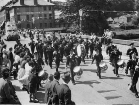
ground in between. In
this 1950’s photo the Clothworkers building is in the top left and Billy
Patterson is leading the Coleraine (Killowen) Fife and Drum Band across
the Bann Bridge. The HT Barrie sheds are in the right middle distance.
The trees of the Manor House (Jackson Hall) are behind the sheds. Religious
Changes At
least five state religions have been practiced in the Killowen area
throughout its long history. These were the Druid, Celtic Christian, Roman
Catholic, Episcopalian Protestant, Puritan and Presbyterian Protestant.
Until
the arrival of Saint Patrick with his Celtic Christianity in 432 AD the
dominant religion in Ireland was Druidism. The Romans may have forced the
Celts and Gales off their land in Europe. Now it was the son of a Roman
nobleman, Patrick, who was bringing them the word of God. Irish raiders
had taken him from the British mainland and he was employed as a
slave-herdsman in Ireland for six years. During that period in Ireland he
became a Christian convert, escaped and then returned as a bishop.
In
540 AD St Carbreus founded a Celtic Christian abbey behind the rath where
the County Hall is now located. The monastery survived until 1213 when
Thomas de Galloway demolished it. The rubble of the monastery, along with
all other stone edifice and headstone in the area provided him with the
material he needed to build Coleraine castle. The church of St Patrick
survived that vandalism and has thrived well in the middle of the town
ever since.
Starting
in AD 1172, Celtic Christianity was steadily replaced by Roman
Catholicism. King Henry VIII then started the dissolution of the
monasteries between 1536 and 1540 and paved the way for Episcopalian
Protestantism. In 1542 Shane O’Boyle, the prior of the Dominican Abbey,
surrendered the Abbey to the King’s Commissioners. Surrendering was a
legal procedure that saved Shane O’Boyle’s life. A refusal to hand
over the Abbey would have been treated as treason, punishable by hanging,
drawing and quartering. O’Boyle’s
surrender may have saved his life but between 1558 and 1614 many other
Dominicans were executed for their faith. That included the friar John
O’Lynn, hanged in Derry in 1607, his brother William soon followed and
then so did William Quinn of Coleraine (Mullan & Donnelly p 90). The
prior Father Ferge was also slain, as were twenty-four friars from
Coleraine. These executions were usually protracted affairs where the
victims were trampled to death by cavalry, torn apart on water wheels,
thrown into the Bann and then stoned to death. These atrocities took place
during the reign of three monarchs, Henry VIII, Elizabeth I and James I.
The latter declared in 1616 that he was not killing Papists for religions
sake or even for saying Mass, but for their refusal to make an oath of
allegiance to the crown.
James
Hamilton soon came into possession of the Dominican Abbey and he sold it
in 1602 to Captain Thomas Phillips. At that time Phillips was developing
Coleraine town as his private enterprise. When the Plantation of Ulster
started in 1609 the abbey became the property of the London Companies and
the parish churches of St Patrick’s and St John the Baptist (Killowen)
were transformed into Episcopalian Protestant churches. For a short period
after the 1642 rebellion Scottish Presbyterian Protestants occupied the
Coleraine area. Then in 1650 the Scots surrendered their power bases in
Ulster to Cromwell’s Puritans.
The
Curfew Bell When
the Plantation started many of the native Irish lost their land and they
were ordered “to
depart with their goods and chattels at or before the first of May next
(1609) into what other part of the realm they pleased.” (Joyce,
paragraph 525). The
Roman Catholic faith was outlawed to the extent that the Protestant
Bishops inherited their land and no Roman Catholics, mere (pure) Irish,
Dissenters or Presbyterians were permitted to reside in Coleraine town.
That restriction zone extended from the Irish Houses on the northwest side
of the town, Laurel Hill on the south and Spittal Hill on the east
(MacLaughlin, p8). Every day before sunset, all Roman Catholics, the mere
(pure) Irish, Dissenters and Presbyterians still inside the restricted
zone were warned to leave by the ringing of the Curfew Bell.
St
Eugene’s Church St
Eugene’s was built at the same time as the first Bann Bridge in 1248,
the Norman era. It was to be used by the soldiers garrisoned at Drumtarsy
Castle and the settlers of Drumtarsy (Machonachie, p6).
The name Eugene is anglicized from the Irish word Cill-Eoghain
meaning the church of Eugene or Owen. According to Mullan and Donnelly
(1992, p 55) the Church of Ireland bishops referred to St Eugene’s in
the 1622 and 1718 Visitation Books. St Eugene’s later became known as St
John the Baptist (1609) and finally as St John the Evangelist (1834). It
was situated within the northern boundary of the present Killowen
graveyard.
At
the start of the Plantation the church was used by the Protestant
settlers, restored in 1616 and renovated in 1690 and 1767. The James
O’Hagan map (1845) refers to the location as the Old Church and then the
Valuation Map (1858) refers to the location as the Parochial House. The
present Protestant church at Killowen was then built in 1830. After that
date the original RC church was used as a Parochial Hall and a schoolroom.
Eventually the old chapel was demolished in 1961 and Killowen Community
Hall was built on the foundations.
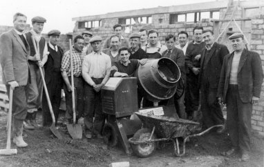
Building
Killowen Community Hall-1961 Rev.
A Maconachie MA, DD., Ned McFadden, Hugh Hutchinson, Jas McFadden, Rev.
Victor Hanson, Jim Dysart, J McCandless, R Newton, John Brolly, Billy
Sloan, Trevor Barr, A Hill, Willie Adams, Jock McGrath, Albert Brown,
Robert McCandless.
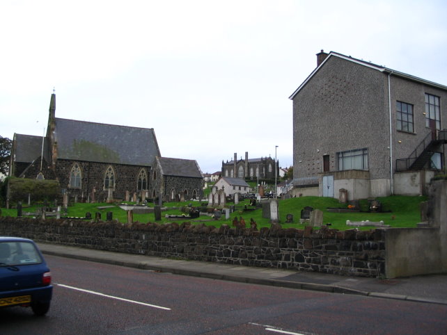
Killowen Church, St Johns' RC Chapel and Maconachie Hall.
St John's Monastery (1080) Was located between Killowen Church and Maconachie Hall.
St Eugene's RC Chapel foundations are below Maconachie Hall.
St
John’s Monastery There
was a much older religious building located between the old chapel and the
new church in Killowen graveyard. St John’s monastery was founded in
1080 and was still visible in 1835. Stokes (1835) talks about the location
in Volume 33 of the Ordnance Survey Memoirs of Ireland, reprinted in 1995
(P. 161). The foundations form a square 28 feet by 27 feet but the sexton
had removed all the masonry by that time. The
Mass Walk The
Roman Catholic parishioners displaced from St Eugene’s during the
Protestant plantation started to attend open air mass on ‘The Mass
Walk’ in the Somerset demesne lands (Mullan & Donnelly, p140). This
was located on the Garrett Screen Road opposite the present Greenmount
Estate. The nearby Screen Road may offer a clue as to the close proximity
of the Mass Walk because the Irish word for shrine is scrin. Populations,
Households and Residents
The
hearth tax alone is not an accurate indicator to the size of the
population. A householder had to pay a tax on each hearth in a particular
house. One house may have several hearths and other houses would have no
hearths and thus didn’t have to pay the hearth tax. The Irish system
involved building a fire in the middle of the room and allowing the smoke
to escape through a hole cut in the roof. In
1663 Coleraine town had 176 households with 292 hearths. Killowen had 18
households with 20 hearths. Page 107 Mullin
|
|||
|
|
|||